Profile №9 BEHI-P009-FFM
Free Frank McWorter
1777–1854
Entrepreneur, Farmer, Land Developer, Town Founder
Overview
TAKEAWAY: McWorter connected enterprise, land, town development, and family freedom. Legal and land records provide firm anchors, while freedom-payment and title chains remain incomplete.
BEHI PROFILE — RESEARCH IN PROGRESS — UPDATED NOVEMBER 4, 2026. EVIDENCE IS CLASSIFIED CLAIM BY CLAIM; ATTRIBUTED ACCOUNTS AND UNRESOLVED RESEARCH QUESTIONS ARE IDENTIFIED THROUGHOUT.
OVERVIEW
Research update — October 19, 2026: A newly inspected 1825 Spencer County, Kentucky, manumission deed records John Bicksler emancipating Keziah and infant Louisa. The claim that Free Frank McWorter purchased Louisa's freedom is now expressly disputed pending reconciliation of family records. See Myths & Disputes and Receipts for the documentary basis and remaining gaps.
Free Frank McWorter was a Kentucky entrepreneur and Illinois farmer and town founder whose economic activity was tied to family freedom. The 1837 Illinois act directly documents his changed legal name and property capacity. Official land-sale entries and attributed town histories provide complementary evidence; the full title and freedom-payment chains remain open.
Production, property, and family freedom
Kentucky enterprise
Institutional accounts connect saltpeter production with the pursuit of freedom.
Illinois land
Official entries provide parcel-specific evidence of acquisition, acreage, and cost.
New Philadelphia
Town founding extends the story from household enterprise to settlement and land development.
Career map based on the inspected land entries, 1837 act, and NPS history of McWorter and New Philadelphia. BEHI analysis: production, property, and freedom form related strands. An exact transfer of particular business earnings into a named freedom payment still requires operating accounts and legal instruments.
The enacted 1837 act changes Free Frank to Frank McWorter.
Three current state entries total 200 acres and $250.
Institutional accounts connect enterprise with freedom purchases.
EXACT ACCOMPLISHMENTS
Three inspected state database entries under FRANK FREE record 200 acres at a combined acquisition cost of $250. Entry dates and patent dates remain distinct.
NPS historical accounts describe McWorter’s founding of New Philadelphia. Original plats, deeds and lot-sale accounts remain separate documentary targets.
Institutional histories connect Kentucky enterprise with family freedom purchases. Individual purchasers, recipients and amounts require transaction-level evidence.
THE RECORD & ITS LIMITS
The enacted law, legislative file, Tanner patent face and current state land entries have been inspected.
Acquisition cost, acreage, lot-sale revenue, profit and estate value are different measures.
Original cash-entry files, assignment endorsements, deed copies, manumission/payment records and probate evidence still require reconciliation.
The enacted 1837 act changes Free Frank to Frank McWorter.
Three current state entries total 200 acres and $250.
Institutional accounts connect enterprise with freedom purchases.
BEHI interprets McWorter's economic activity through identifiable legal and land records. The overall profile remains under research.
What Would Move This Profile Forward?
These are the next evidence priorities for strengthening this Profile. Each identifies a concrete research step and what it could help establish.
- Connect land entries to completed ownership
Recover federal cash-entry files, endorsement-bearing patents and corresponding Pike County deeds. These would extend the acquired land-register evidence into an authenticated title chain.
- Document the town plat and lot transfers
Obtain the original New Philadelphia plat and complete lot-sale instruments. These would clarify parcel boundaries, buyers, terms and transactions.
- Reconcile individual freedom purchases
Locate the remaining manumission instruments, payment records and related testimony. These would establish person-by-person dates and amounts while distinguishing McWorter’s actions from later family purchases.
- Complete the estate and 1858 transfer record
Inspect probate accounts and both original 1858 deeds, including the lot schedules and grantor authority. These would test the reported estate transfers and distinguish sale terms from received payments.
Read the Research Gaps & Open Questions for the unresolved issues and evidence limits. New material is reviewed before claims or classifications change.
THE RECEIPTS OR EVIDENCE SUPPORTING THIS PROFILE
Evidence labels apply to individual claims. Read the evidence guide and content-condition definitions.
| SOURCE / LOCATOR | RECORD / CONTEXT | DATE / PERIOD | EVIDENCE STATUS | SUPPORT / LIMITS |
|---|---|---|---|---|
| Enrolled Law 2031 — name change | Primary legislative act | January 19, 1837 | VERIFIED | Illinois State Archives, Enrolled Laws No. 2031, HR 18, Box 48; delivered three-page scan reinspected. Page 1 changes Free Frank to Frank McWorter, authorizes suing/being sued, pleading/being impleaded and purchasing/conveying property under the new name, and extends the changed surname to his children. Governor Joseph Duncan approved January 19, 1837. This is an enacted act, not the underlying petition or an incorporation. |
| Martin Tanner military land patent | Primary federal patent copy | March 16, 1818 | VERIFIED | Inspected one-page file titled Martin Tanner Legal Desc. Warrant 15,424 grants Martin Tanner 160 acres, SE quarter Section 22, Township 4 South, Range 5 West, Illinois Military Tract. No assignment to Elliott or McWorter appears on this inspected face. It establishes federal origin of the tract, not the complete later chain. |
| Illinois land-sale database — FRANK FREE 0233794 | Official archival database | January 11, 1833 | VERIFIED | Current detail record inspected: FRANK FREE; N2NEMA, Section 27; T4S R5W, fourth meridian, Pike County; 80 acres at $1.25 per acre, total $100; original-entry locator volume 702, page 127. The corresponding two-page original register scan was subsequently received and inspected; its Free Frank entry corroborates the January 11, 1833 acquisition. The scan is retained pending public reproduction-rights review. Federal cash-entry files, patent chronology and subsequent title transfers remain separate research targets; an entry date is not a patent date. |
| Illinois land-sale database — FRANK FREE 0252560 | Official archival database | February 12, 1836 | VERIFIED | Current detail record inspected: FRANK FREE; W2SW, Section 26; T4S R5W, fourth meridian, Pike County; 80 acres at $1.25 per acre, total $100; original-entry locator volume 701, page 021. The corresponding Volume 701, page 21 register scans were subsequently received, inspected and displayed in Receipts, corroborating this indexed transaction. Federal cash-entry files, patent chronology and subsequent title transfers remain separate research targets; an entry date is not a patent date. |
| Illinois land-sale database — FRANK FREE 0252559 | Official archival database | April 23, 1836 | VERIFIED | Current detail record inspected: FRANK FREE; NESW, Section 26; T4S R5W, fourth meridian, Pike County; 40 acres at $1.25 per acre, total $50; original-entry locator volume 701, page 021. The corresponding Volume 701, page 21 register scans were subsequently received, inspected and displayed in Receipts, corroborating this indexed transaction. Federal cash-entry files, patent chronology and subsequent title transfers remain separate research targets; an entry date is not a patent date. |
| NPS historical account — McWorter and New Philadelphia | Institutional interpretation | Modern institutional interpretation | ATTRIBUTED | Reports 1777–1854 life dates, Kentucky enterprise, family freedom purchases, town founding, and a cumulative 16 people/$14,000 account. The narrative includes instructions to descendants for purchases after his death; do not assert all 16 purchases were completed in his lifetime. No modern-dollar conversion is adopted. |
Background
TAKEAWAY: Institutional accounts describe McWorter’s early life. The inspected 1825 deed names Bicksler as emancipator of Keziah and infant Louisa; it does not document a purchase by McWorter.
BACKGROUND
1825 family-freedom documentation: A newly inspected Spencer County manumission deed, dated and acknowledged March 14, 1825, records John Bicksler freeing Keziah and her infant daughter Louisa. Dr. Claire Martin's reconstruction links the child to the later Louisa Clark McWorter, but the intervening documentary chain is still under examination. The deed does not name Free Frank as the purchaser of Louisa's freedom.
Institutional histories place McWorter's birth in 1777 in South Carolina and describe enslavement, migration to Kentucky, marriage to Lucy and the development of independent enterprise. These biographical accounts are retained with attribution while original identity and freedom records are matched.
Freedom as a family chronology
1817 · Lucy
Institutional histories place Lucy’s freedom before Frank’s.
1819 · Frank
His reported freedom precedes the move toward Illinois land and settlement.
Later generations
Children and descendants have their own records, transactions, and contributions.
Dates attributed to NPS history of McWorter and New Philadelphia; original manumission and payment instruments remain to be matched. The sequence preserves Lucy’s place in the story. Name variants, repeated given names, and post-1854 transactions require checks against generation, location, and date before attribution to the founder.
HISTORICAL & ECONOMIC CONTEXT
Lucy’s freedom and the family's work belong in the account.
Free Frank, Frank McWorter and McWhorter require context.
The founder, Frank Jr., Solomon, Squire and Commodore must remain distinct.
THE RECORD & ITS LIMITS
Institutions report Lucy's freedom in 1817 and Frank's in 1819. This audit has not recovered their original manumission/payment instruments.
The cited deed is dated 1830; Porter’s reproduced recollection describes settlement in 1831. Purchase and arrival need not be the same date.
The inspected 1837 act establishes the changed legal name. Family finding-aid labels are preliminary and cannot independently identify each person.
Lucy’s freedom and the family's work belong in the account.
Free Frank, Frank McWorter and McWhorter require context.
The founder, Frank Jr., Solomon, Squire and Commodore must remain distinct.
Match identity before assigning property, a signature, a transaction or an estate to the founder.
EVIDENCE & CONTEXT
| SOURCE | DESCRIPTION | DATE | EVIDENCE CLASSIFICATION | NOTES |
|---|---|---|---|---|
| Enrolled Law 2031 — name change | Primary legislative act | January 19, 1837 | VERIFIED | Illinois State Archives, Enrolled Laws No. 2031, HR 18, Box 48; delivered three-page scan reinspected. Page 1 changes Free Frank to Frank McWorter, authorizes suing/being sued, pleading/being impleaded and purchasing/conveying property under the new name, and extends the changed surname to his children. Governor Joseph Duncan approved January 19, 1837. This is an enacted act, not the underlying petition or an incorporation. |
| Joseph Porter deposition via Walker | Scholarly reproduction | March 14, 1856 deposition; 1983 publication | ATTRIBUTED | Juliet E. K. Walker, Free Frank: A Black Pioneer on the Antebellum Frontier, inspected selected pages 64–68 and note p. 188. Porter describes an exchange and Elliott acquiring from Oldham; the cited deed recites $200. Original deposition and Oldham identities require reconciliation. Smithsonian supplied scans for research; their images are not republished. |
| Kentucky enterprise and freedom records | Original acquisition pending | 1810s–1830s leads | ATTRIBUTED | Saltpeter enterprise is described in institutional histories. Pulaski Deed Book 7-1, pp. 55–56 reportedly mentions stills, tubs and equipment; original instrument not recovered. Saltpeter and distilling evidence must remain distinct. Lucy's 1817 and Frank's 1819 freedom dates are institutional accounts until manumission/payment records are matched. |
| NPS historical account — McWorter and New Philadelphia | Institutional interpretation | Modern institutional interpretation | ATTRIBUTED | Reports 1777–1854 life dates, Kentucky enterprise, family freedom purchases, town founding, and a cumulative 16 people/$14,000 account. The narrative includes instructions to descendants for purchases after his death; do not assert all 16 purchases were completed in his lifetime. No modern-dollar conversion is adopted. |
| Gerald McWorter family archive — finding aid | Archival finding aid | Collection donated 2026 | VERIFIED | Inspected 1542021_002.pdf, University of Illinois Archives series 15/42/21, Series 2, pp. 1–4. Identifies originals and copies of letters, deeds, photographs and later family materials, and cautions about preliminary generation labels and photograph dates. Finding aid confirms research targets, not contents of uninspected originals. No authenticated founder portrait cleared. |
The Problem
TAKEAWAY: Enslavement and later racial restrictions constrained McWorter’s activities. Each freedom transaction, property right, and legal change requires its own evidence.
THE PROBLEM
McWorter's enterprises developed under enslavement and later racial restrictions on movement, legal participation and schooling. Economic activity could support the purchase of freedom, but each transaction and legal change needs its own evidence.
What the 1837 law changes—and what it leaves open
A legal name
The approved act changes Free Frank’s name to Frank McWorter and extends the surname to his children.
A name used in transactions
It authorizes litigation and purchasing or conveying property under the changed name.
Separate rights questions
Freedom status, schooling, and wider racial restrictions require their own legal and documentary history.
Primary anchor: Enrolled Law 2031, HR 18, Box 48, approved January 19, 1837; delivered scan, p. 1. The diagram follows the act’s scope. The 1853 school-tax petition is a distinct civic record, not proof of a law enacted or a verified signature by Free Frank.
DIMENSIONS OF THE PROBLEM
Original instruments are needed to verify recipients and amounts.
The act explicitly addresses purchasing and conveying property.
The later petition concerns public education and property-supported funds.
HOW THE PROBLEM SHOWED UP
The act authorizes use of the changed name in litigation and property transactions. It is not an emancipation document.
The packet is a request to the legislature, not proof that its proposals became law.
Names read as C. M. Worter and S. M. Worter appear. The inspected page does not clearly identify Free Frank as a signer.
Original instruments are needed to verify recipients and amounts.
The act explicitly addresses purchasing and conveying property.
The later petition concerns public education and property-supported funds.
The records support distinct legal and civic questions. They do not establish that one act removed every racial restriction.
EVIDENCE & CONTEXT
| SOURCE | DESCRIPTION | DATE | EVIDENCE CLASSIFICATION | NOTES |
|---|---|---|---|---|
| Enrolled Law 2031 — name change | Primary legislative act | January 19, 1837 | VERIFIED | Illinois State Archives, Enrolled Laws No. 2031, HR 18, Box 48; delivered three-page scan reinspected. Page 1 changes Free Frank to Frank McWorter, authorizes suing/being sued, pleading/being impleaded and purchasing/conveying property under the new name, and extends the changed surname to his children. Governor Joseph Duncan approved January 19, 1837. This is an enacted act, not the underlying petition or an incorporation. |
| House Bill 3 — legislative file | Primary legislative proceedings | 1837 | VERIFIED | Illinois State Archives, 10th General Assembly, HB 3; seven-page delivered file reinspected. Page 3 committee report refers to a petition and proposes the name change; page 1 amendment addresses children; page 5 preserves a draft and legislative endorsements. The report's reference to a petition does not establish that the petition itself survives in this packet. |
| School-tax petition — file 820 | Primary petition | 1853 | VERIFIED | Illinois State Archives, 18th General Assembly, file 820; five-page delivered packet reinspected. Petition seeks education provision for children of color in relation to property-supported school funds. Signature page includes names read as C. M. Worter and S. M. Worter. It does not clearly identify Free Frank as a signer; no personal tax payment or enacted outcome is verified. |
| Kentucky enterprise and freedom records | Original acquisition pending | 1810s–1830s leads | ATTRIBUTED | Saltpeter enterprise is described in institutional histories. Pulaski Deed Book 7-1, pp. 55–56 reportedly mentions stills, tubs and equipment; original instrument not recovered. Saltpeter and distilling evidence must remain distinct. Lucy's 1817 and Frank's 1819 freedom dates are institutional accounts until manumission/payment records are matched. |
What He Built
TAKEAWAY: McWorter is associated with saltpeter production, farming, and New Philadelphia. Land entries, plat references, and later deed research represent different layers of evidence.
WHAT HE BUILT
McWorter is associated with Kentucky saltpeter production, an Illinois farm and the town of New Philadelphia. The town's recorded-plat locator, public-land entries and later deed compilation are different layers of that history.
A town organized into saleable lots
NPS describes 144 lots in the town laid out in 1836, sold to Black and white settlers.
The farm and town were related enterprises, with different parcels and operating questions.
Dimensions and count attributed to NPS history of McWorter and New Philadelphia. This is a lot schematic, not the recorded plat, a parcel survey, or a reconstruction of the street plan. Original plat locator: Pike County Deed Book 9, p. 183. Reported town acreage is not total land owned.
THE ENTERPRISE SYSTEM
Original operating and equipment records remain targets.
Official database entries identify specific parcels and costs.
The plat and lot-sale instruments require item-level reconciliation.
THE RECORD & ITS LIMITS
NPS accounts describe 42 acres and 144 lots; recorded plat locator is Pike Deed Book 9, p. 183. Original plat not freshly inspected here.
The platted town area is not all land owned, and later additions cannot be assigned to 1836 without records.
The compiled deed workbook repeats transactions across lots. Multiple rows do not establish multiple independent sales.
No incorporated company is established by this audit. The legal name act is personal legislation.
Original operating and equipment records remain targets.
Official database entries identify specific parcels and costs.
The plat and lot-sale instruments require item-level reconciliation.
An enterprise can be historically significant without a surviving corporate ledger. Its economic measures must still be supported.
EVIDENCE & CONTEXT
| SOURCE | DESCRIPTION | DATE | EVIDENCE CLASSIFICATION | NOTES |
|---|---|---|---|---|
| Enrolled Law 2031 — name change | Primary legislative act | January 19, 1837 | VERIFIED | Illinois State Archives, Enrolled Laws No. 2031, HR 18, Box 48; delivered three-page scan reinspected. Page 1 changes Free Frank to Frank McWorter, authorizes suing/being sued, pleading/being impleaded and purchasing/conveying property under the new name, and extends the changed surname to his children. Governor Joseph Duncan approved January 19, 1837. This is an enacted act, not the underlying petition or an incorporation. |
| Illinois land-sale database — FRANK FREE 0233794 | Official archival database | January 11, 1833 | VERIFIED | Current detail record inspected: FRANK FREE; N2NEMA, Section 27; T4S R5W, fourth meridian, Pike County; 80 acres at $1.25 per acre, total $100; original-entry locator volume 702, page 127. The corresponding two-page original register scan was subsequently received and inspected; its Free Frank entry corroborates the January 11, 1833 acquisition. The scan is retained pending public reproduction-rights review. Federal cash-entry files, patent chronology and subsequent title transfers remain separate research targets; an entry date is not a patent date. |
| Illinois land-sale database — FRANK FREE 0252560 | Official archival database | February 12, 1836 | VERIFIED | Current detail record inspected: FRANK FREE; W2SW, Section 26; T4S R5W, fourth meridian, Pike County; 80 acres at $1.25 per acre, total $100; original-entry locator volume 701, page 021. The corresponding Volume 701, page 21 register scans were subsequently received, inspected and displayed in Receipts, corroborating this indexed transaction. Federal cash-entry files, patent chronology and subsequent title transfers remain separate research targets; an entry date is not a patent date. |
| Illinois land-sale database — FRANK FREE 0252559 | Official archival database | April 23, 1836 | VERIFIED | Current detail record inspected: FRANK FREE; NESW, Section 26; T4S R5W, fourth meridian, Pike County; 40 acres at $1.25 per acre, total $50; original-entry locator volume 701, page 021. The corresponding Volume 701, page 21 register scans were subsequently received, inspected and displayed in Receipts, corroborating this indexed transaction. Federal cash-entry files, patent chronology and subsequent title transfers remain separate research targets; an entry date is not a patent date. |
| New Philadelphia plat locator | Government map interpretation / locator | 1836 | ATTRIBUTED | NPS identifies Pike County Deed Book 9, p. 183 and later atlas/map reproductions. Institutional accounts describe a 42-acre town and 144 lots. Original recorded plat and acknowledgment still require item-level reinspection; the town area is not total land ownership. |
| New Philadelphia land-deed spreadsheet | Compiled deed research | Historical deeds / undated compilation | ATTRIBUTED | Downloaded and inspected compiled workbook. Rows repeat a transaction across multiple block/lot entries; several Frank McWorter entries date after the founder's 1854 death. Row counts are not transaction counts; identify Frank Jr., heirs and representatives before attributing later sales. Underlying instruments and consideration must be checked. |
| Kentucky enterprise and freedom records | Original acquisition pending | 1810s–1830s leads | ATTRIBUTED | Saltpeter enterprise is described in institutional histories. Pulaski Deed Book 7-1, pp. 55–56 reportedly mentions stills, tubs and equipment; original instrument not recovered. Saltpeter and distilling evidence must remain distinct. Lucy's 1817 and Frank's 1819 freedom dates are institutional accounts until manumission/payment records are matched. |
Accomplishments
TAKEAWAY: Inspected law and land records establish specific legal and acquisition findings. Town founding and family-freedom narratives retain qualifications while original transactions are reconciled.
ACCOMPLISHMENTS
The strongest inspected anchors are legal recognition under the McWorter name and identifiable land purchases. Town founding and family freedom are documented in institutional histories, with original transactions still being reconciled.
Three achievements, distinct records
The law and database entries support narrow, identifiable findings. Town and freedom narratives retain their institutional attribution while original plats, deeds, and payments are reconciled. BEHI’s assessment of significance does not depend on an unsupported wealth ranking or a universal first-town claim.
ACCOMPLISHMENT LEDGER
Dates and evidence classifications apply to the specific findings below. Economic significance is BEHI analysis; evidence limits remain attached to each entry.
| DATE / PERIOD | ACCOMPLISHMENT | ECONOMIC SIGNIFICANCE | SOURCE / LOCATOR | EVIDENCE CLASSIFICATION | EVIDENCE LIMITS |
|---|---|---|---|---|---|
| 1833–1836 | Recorded Illinois land acquisition Three inspected state entries record 200 acres at a combined acquisition cost of $250. | Documents identifiable land transactions underlying the property enterprise. | Illinois land-sale database — FRANK FREE 0233794 Illinois land-sale database — FRANK FREE 0252560 Illinois land-sale database — FRANK FREE 0252559 Purchase numbers 0233794, 0252560 and 0252559. | VERIFIED | Verification covers the database entries. Entry dates are not patent dates; cost is not profit or net worth. |
| 1836 | New Philadelphia town founding NPS historical accounts describe McWorter’s town-founding work. | Connects land development with settlement and community formation. | NPS historical account — McWorter and New Philadelphia Institutional history of McWorter and New Philadelphia. | ATTRIBUTED | Original plats, deeds and lot-sale transactions remain under reconciliation; no universal first-town claim is adopted. |
| January 19, 1837 | Legal recognition under the McWorter name The enacted act changes Free Frank’s name and authorizes specified litigation and property transactions under it. | Provides a legal framework for transactions under the changed name. | Enrolled Law 2031 — name change Enrolled Law 2031, HR 18, Box 48, p. 1; repository link. | VERIFIED | This is a name-change act, not an emancipation instrument or proof that all racial restrictions ended. |
ACCOMPLISHMENT CATEGORIES
An enacted law specifies the new name and property capacity.
Three official database entries identify purchases.
Institutional accounts describe sales to Black and white settlers.
THE RECORD & ITS LIMITS
Use the specific institutional formulation: first known U.S. town platted and legally registered by African Americans. A broad first-town-ever claim requires wider comparative evidence.
The familiar 16-person/$14,000 account is cumulative and attributed. Distinguish the founder's lifetime payments from later family purchases.
Land ownership and freedom spending do not establish audited net worth or a national wealth rank.
An enacted law specifies the new name and property capacity.
Three official database entries identify purchases.
Institutional accounts describe sales to Black and white settlers.
Preserve both the significance of the work and the limits of the surviving account.
EVIDENCE & CONTEXT
| SOURCE | DESCRIPTION | DATE | EVIDENCE CLASSIFICATION | NOTES |
|---|---|---|---|---|
| Enrolled Law 2031 — name change | Primary legislative act | January 19, 1837 | VERIFIED | Illinois State Archives, Enrolled Laws No. 2031, HR 18, Box 48; delivered three-page scan reinspected. Page 1 changes Free Frank to Frank McWorter, authorizes suing/being sued, pleading/being impleaded and purchasing/conveying property under the new name, and extends the changed surname to his children. Governor Joseph Duncan approved January 19, 1837. This is an enacted act, not the underlying petition or an incorporation. |
| Illinois land-sale database — FRANK FREE 0233794 | Official archival database | January 11, 1833 | VERIFIED | Current detail record inspected: FRANK FREE; N2NEMA, Section 27; T4S R5W, fourth meridian, Pike County; 80 acres at $1.25 per acre, total $100; original-entry locator volume 702, page 127. The corresponding two-page original register scan was subsequently received and inspected; its Free Frank entry corroborates the January 11, 1833 acquisition. The scan is retained pending public reproduction-rights review. Federal cash-entry files, patent chronology and subsequent title transfers remain separate research targets; an entry date is not a patent date. |
| Illinois land-sale database — FRANK FREE 0252560 | Official archival database | February 12, 1836 | VERIFIED | Current detail record inspected: FRANK FREE; W2SW, Section 26; T4S R5W, fourth meridian, Pike County; 80 acres at $1.25 per acre, total $100; original-entry locator volume 701, page 021. The corresponding Volume 701, page 21 register scans were subsequently received, inspected and displayed in Receipts, corroborating this indexed transaction. Federal cash-entry files, patent chronology and subsequent title transfers remain separate research targets; an entry date is not a patent date. |
| Illinois land-sale database — FRANK FREE 0252559 | Official archival database | April 23, 1836 | VERIFIED | Current detail record inspected: FRANK FREE; NESW, Section 26; T4S R5W, fourth meridian, Pike County; 40 acres at $1.25 per acre, total $50; original-entry locator volume 701, page 021. The corresponding Volume 701, page 21 register scans were subsequently received, inspected and displayed in Receipts, corroborating this indexed transaction. Federal cash-entry files, patent chronology and subsequent title transfers remain separate research targets; an entry date is not a patent date. |
| NPS historical account — McWorter and New Philadelphia | Institutional interpretation | Modern institutional interpretation | ATTRIBUTED | Reports 1777–1854 life dates, Kentucky enterprise, family freedom purchases, town founding, and a cumulative 16 people/$14,000 account. The narrative includes instructions to descendants for purchases after his death; do not assert all 16 purchases were completed in his lifetime. No modern-dollar conversion is adopted. |
Economic Impact
TAKEAWAY: Three recorded purchases total 200 acres for $250. This is an acquisition subtotal, not total holdings, town revenue, profit, or net worth.
ECONOMIC IMPACT
The verified database subtotal is 200 acres purchased for $250 across three entries under FRANK FREE. That is a documented acquisition subtotal, not total holdings, town revenue, profit or net worth. All amounts are historical nominal dollars.
Early New Philadelphia lot sale (1838; attributed): Published archaeological deed research reports Frank McWorter conveying Block 3, Lot 4 to Henry Brown in 1838. Original deed terms and consideration remain unverified. The same compilation lists a 1854 McWorter-to-Elick Clark entry for this lot, but intervening ownership and grantor identity have not been established.
Three land entries: acreage and acquisition cost
Subtotal: 200 acres · $250 · $1.25 per acre
Verified database-entry contents · historical dollars. Bars compare acreage, with a common zero baseline and an 80-acre maximum. The subtotal excludes Commodore’s separate purchase lead and is not all land owned. The first entry’s January 11, 1833 date is now corroborated by the received Volume 702 register scan. Earlier 1834/1835 readings remain in the research history; federal cash-entry and patent dates still require separate reconciliation. These are acquisition costs, not lot-sale revenue, profit, or estate value.
KEY ECONOMIC INDICATORS
Each measure identifies its entity, period, source and evidence limits. Dollar amounts are nominal historical U.S. dollars. Assets, revenue, profit, transaction amounts and employment measures are distinct. “Not yet established” identifies a research gap, not zero or “not applicable.”
| MEASURE / VALUE | ENTITY / PERIOD | SOURCE / LOCATOR | CONTENT CONDITION / EVIDENCE CLASSIFICATION | INTERPRETATION / LIMITS |
|---|---|---|---|---|
| Recorded land purchase 80 acres / $100 | FRANK FREE entry January 11, 1833 (database date) | Illinois land-sale database 0233794; vol. 702, p. 127. | Documented VERIFIED | Database entry; date differs from earlier narrative dates. Not total landholdings. |
| Recorded land purchase 80 acres / $100 | FRANK FREE entry February 12, 1836 | Illinois land-sale database 0252560; vol. 701, p. 021. | Documented VERIFIED | Purchase amount, not subsequent market value or profit. |
| Recorded land purchase 40 acres / $50 | FRANK FREE entry April 23, 1836 | Illinois land-sale database 0252559; vol. 701, p. 021. | Documented VERIFIED | Purchase amount; separate Commodore Frank entry excluded. |
| Annual operating profit Not yet established | McWorter enterprises Reporting period not established | Research gap; see Evidence & Context and Receipts. | Not yet established Evidence classification: not assigned to an unresolved answer. | Land acquisition amounts do not establish earnings from farming, production or town development. Research Gap: Annual operating profit |
For evidence-label definitions, see the Receipts evidence guide.
THE RECORD & ITS LIMITS
80 + 80 + 40 = 200 acres; $100 + $100 + $50 = $250. Commodore's separate 40-acre/$50 lead is excluded.
The current first-entry date is January 11, 1833, corroborated by the received Volume 702 register scan. Earlier 1834/1835 readings are superseded for this state entry; the federal cash-entry file and patent chronology remain unresolved.
Walker reproduces a deed reciting $200 for 160 acres and a deposition describing exchange. Consideration and form of payment require original reconciliation.
The attributed $14,000 total is not business profit, and no modern-dollar conversion is presented.
No verified series of saltpeter sales, farm income, town-lot receipts, wages, debt or estate net worth is supplied.
80 acres/$100; database date January 11, 1833.
80 acres/$100; February 12, 1836.
40 acres/$50; April 23, 1836.
Do not combine family purchases, duplicate lot rows or parcels from different sources into an unsupported total.
EVIDENCE & CONTEXT
| SOURCE | DESCRIPTION | DATE | EVIDENCE CLASSIFICATION | NOTES |
|---|---|---|---|---|
| Illinois land-sale database — FRANK FREE 0233794 | Official archival database | January 11, 1833 | VERIFIED | Current detail record inspected: FRANK FREE; N2NEMA, Section 27; T4S R5W, fourth meridian, Pike County; 80 acres at $1.25 per acre, total $100; original-entry locator volume 702, page 127. The corresponding two-page original register scan was subsequently received and inspected; its Free Frank entry corroborates the January 11, 1833 acquisition. The scan is retained pending public reproduction-rights review. Federal cash-entry files, patent chronology and subsequent title transfers remain separate research targets; an entry date is not a patent date. |
| Illinois land-sale database — FRANK FREE 0252560 | Official archival database | February 12, 1836 | VERIFIED | Current detail record inspected: FRANK FREE; W2SW, Section 26; T4S R5W, fourth meridian, Pike County; 80 acres at $1.25 per acre, total $100; original-entry locator volume 701, page 021. The corresponding Volume 701, page 21 register scans were subsequently received, inspected and displayed in Receipts, corroborating this indexed transaction. Federal cash-entry files, patent chronology and subsequent title transfers remain separate research targets; an entry date is not a patent date. |
| Illinois land-sale database — FRANK FREE 0252559 | Official archival database | April 23, 1836 | VERIFIED | Current detail record inspected: FRANK FREE; NESW, Section 26; T4S R5W, fourth meridian, Pike County; 40 acres at $1.25 per acre, total $50; original-entry locator volume 701, page 021. The corresponding Volume 701, page 21 register scans were subsequently received, inspected and displayed in Receipts, corroborating this indexed transaction. Federal cash-entry files, patent chronology and subsequent title transfers remain separate research targets; an entry date is not a patent date. |
| Federal cash certificates 511, 6728, 7664 | Prior federal research / acquisition | 1830s acquisition leads | ATTRIBUTED | Previous research links these certificate numbers to the three Free Frank parcels. Complete original case files were requested under RR1R-26-88394; delivery not confirmed here. The state database and the subsequently inspected Volume 702 register support January 11, 1833 for the first state entry. Earlier 1834/1835 readings remain in the research history; the federal file dates and patent chronology still require reconciliation. |
| Commodore Frank — certificate 8589 | Separate family acquisition | June 10, 1836 lead | ATTRIBUTED | Earlier research gives 40 acres/$50, NW quarter SE quarter Section 26. This is Commodore's separate acquisition. Exclude it from Free Frank's three-entry subtotal; original record not reinspected in this audit. |
| Elliott to Free Frank — deed | Prior deed transcription | September 13, 1830 lead | ATTRIBUTED | Pike County Deed Book 23, p. 46; earlier research and Walker's inspected reproduction describe 160 acres, SE quarter Section 22, T4S R5W, and $200 consideration. Original county page not recovered for fresh reinspection. Do not treat recited consideration as proof of a cash-only transaction. |
| Joseph Porter deposition via Walker | Scholarly reproduction | March 14, 1856 deposition; 1983 publication | ATTRIBUTED | Juliet E. K. Walker, Free Frank: A Black Pioneer on the Antebellum Frontier, inspected selected pages 64–68 and note p. 188. Porter describes an exchange and Elliott acquiring from Oldham; the cited deed recites $200. Original deposition and Oldham identities require reconciliation. Smithsonian supplied scans for research; their images are not republished. |
| NPS historical account — McWorter and New Philadelphia | Institutional interpretation | Modern institutional interpretation | ATTRIBUTED | Reports 1777–1854 life dates, Kentucky enterprise, family freedom purchases, town founding, and a cumulative 16 people/$14,000 account. The narrative includes instructions to descendants for purchases after his death; do not assert all 16 purchases were completed in his lifetime. No modern-dollar conversion is adopted. |
MEASURE THE TRANSACTION THE RECORD SHOWS
Do not combine family purchases, duplicate lot rows or parcels from different sources into an unsupported total.
1858 estate-property circulation (published reconstruction): University of Maryland archaeological researchers report 72 New Philadelphia lots conveyed from Frank McWorter's estate to George Conrad and D. Kitright in 1858, and then from Conrad to Solomon McWorter, with a Block 2 exception. Estate value, consideration and legal authority remain unverified without the original deeds.
Timeline
TAKEAWAY: Event dates, recording dates, and later family transactions are distinct. The 1825 manumission is not a verified freedom payment by McWorter.
TIMELINE
March 14, 1825 — manumission instrument: John Bicksler signed a deed freeing Keziah and her infant daughter Louisa in Spencer County, Kentucky. March 14, 1825 — court acknowledgment: county court acknowledged the instrument. This is a related-family event, not a documented emancipation payment by Free Frank; identification with the later Louisa Clark McWorter remains under research.
This chronology separates event dates, entry dates, later filing dates and retrospective accounts. It avoids assigning later family transactions to the founder.
1838 — Early lot conveyance (attributed): Archaeological deed research identifies Frank McWorter to Henry Brown, Block 3, Lot 4, New Philadelphia; original deed pending. 1854 — Unresolved chain: A compiled McWorter-to-Elick Clark entry concerns the same lot; confirm actual grantor and any intervening deeds.
From freedom chronology to land and law
- 1817–1819Family freedom
Institutional accounts date Lucy’s and Frank’s freedom.
- 1830–1831Purchase & settlement
Deed date and settlement recollection describe different events.
- 1833 / 1836Public-land entries
Current state entries identify specific acquisitions; first date remains under reconciliation.
- 1836Town laid out
Institutional history dates New Philadelphia’s founding.
- 1837Name act approved
January 19 approval establishes the changed legal name.
- 1854 & afterFamily continuity
Founder’s death separates his lifetime activity from later family efforts.
Sources and classifications follow in the detailed chronology. This visual separates an attributed life event, an acquisition date, a settlement recollection, and a legislative approval. Dates are not treated as equally verified merely because they appear on one timeline.
TIMELINE AT A GLANCE
1817/1819 reported; original instruments pending.
1818 patent origin, 1830 deed lead, 1833/1836 database entries.
1853 civic record and post-1854 transactions require identities.
THE RECORD & ITS LIMITS
Birth in South Carolina is reported in institutional accounts.
Lucy and Frank freedom dates are attributed; payment instruments remain open.
March 16 Tanner patent establishes federal origin of the Section 22 tract.
September 13 deed lead and next-spring settlement account remain distinct.
Current database entries: January 11, 1833; February 12 and April 23, 1836.
Town founding attributed to 1836; enacted name-change act approved January 19, 1837.
July 10 filing is an assignment-index lead, not the date of the 1818 federal grant.
School petition preserved; institutional death year 1854. Later sales and freedom purchases require family/estate attribution.
1817/1819 reported; original instruments pending.
1818 patent origin, 1830 deed lead, 1833/1836 database entries.
1853 civic record and post-1854 transactions require identities.
A purchase date, patent date, deed execution date and recording date may differ.
EVIDENCE & CONTEXT
| SOURCE | DESCRIPTION | DATE | EVIDENCE CLASSIFICATION | NOTES |
|---|---|---|---|---|
| Enrolled Law 2031 — name change | Primary legislative act | January 19, 1837 | VERIFIED | Illinois State Archives, Enrolled Laws No. 2031, HR 18, Box 48; delivered three-page scan reinspected. Page 1 changes Free Frank to Frank McWorter, authorizes suing/being sued, pleading/being impleaded and purchasing/conveying property under the new name, and extends the changed surname to his children. Governor Joseph Duncan approved January 19, 1837. This is an enacted act, not the underlying petition or an incorporation. |
| School-tax petition — file 820 | Primary petition | 1853 | VERIFIED | Illinois State Archives, 18th General Assembly, file 820; five-page delivered packet reinspected. Petition seeks education provision for children of color in relation to property-supported school funds. Signature page includes names read as C. M. Worter and S. M. Worter. It does not clearly identify Free Frank as a signer; no personal tax payment or enacted outcome is verified. |
| Martin Tanner military land patent | Primary federal patent copy | March 16, 1818 | VERIFIED | Inspected one-page file titled Martin Tanner Legal Desc. Warrant 15,424 grants Martin Tanner 160 acres, SE quarter Section 22, Township 4 South, Range 5 West, Illinois Military Tract. No assignment to Elliott or McWorter appears on this inspected face. It establishes federal origin of the tract, not the complete later chain. |
| Illinois land-sale database — FRANK FREE 0233794 | Official archival database | January 11, 1833 | VERIFIED | Current detail record inspected: FRANK FREE; N2NEMA, Section 27; T4S R5W, fourth meridian, Pike County; 80 acres at $1.25 per acre, total $100; original-entry locator volume 702, page 127. The corresponding two-page original register scan was subsequently received and inspected; its Free Frank entry corroborates the January 11, 1833 acquisition. The scan is retained pending public reproduction-rights review. Federal cash-entry files, patent chronology and subsequent title transfers remain separate research targets; an entry date is not a patent date. |
| Illinois land-sale database — FRANK FREE 0252560 | Official archival database | February 12, 1836 | VERIFIED | Current detail record inspected: FRANK FREE; W2SW, Section 26; T4S R5W, fourth meridian, Pike County; 80 acres at $1.25 per acre, total $100; original-entry locator volume 701, page 021. The corresponding Volume 701, page 21 register scans were subsequently received, inspected and displayed in Receipts, corroborating this indexed transaction. Federal cash-entry files, patent chronology and subsequent title transfers remain separate research targets; an entry date is not a patent date. |
| Illinois land-sale database — FRANK FREE 0252559 | Official archival database | April 23, 1836 | VERIFIED | Current detail record inspected: FRANK FREE; NESW, Section 26; T4S R5W, fourth meridian, Pike County; 40 acres at $1.25 per acre, total $50; original-entry locator volume 701, page 021. The corresponding Volume 701, page 21 register scans were subsequently received, inspected and displayed in Receipts, corroborating this indexed transaction. Federal cash-entry files, patent chronology and subsequent title transfers remain separate research targets; an entry date is not a patent date. |
| Tanner assignment / tract index | Prior index transcription | Filed July 10, 1840 lead | ATTRIBUTED | Pike Book 22, p. 381 and Book 23, p. 46; earlier index reading says assigned on original. The endorsement-bearing original and intermediate transfers remain unrecovered. Do not draw a completed Tanner-to-Elliott chain from the patent face alone. |
| NPS historical account — McWorter and New Philadelphia | Institutional interpretation | Modern institutional interpretation | ATTRIBUTED | Reports 1777–1854 life dates, Kentucky enterprise, family freedom purchases, town founding, and a cumulative 16 people/$14,000 account. The narrative includes instructions to descendants for purchases after his death; do not assert all 16 purchases were completed in his lifetime. No modern-dollar conversion is adopted. |
DATES WITH THEIR DOCUMENT TYPES
A purchase date, patent date, deed execution date and recording date may differ.
1836: New Philadelphia plat, Pike County Deed Book 9:183 (reproduced in a 2010 University of Maryland archaeological report). 1854: Free Frank dies. 1858 (reported): Estate conveys 72 lots to Conrad and D. Kitright; Conrad subsequently conveys to Solomon McWorter, except certain Block 2 property. Original documents and dates pending.
No verified records are currently published in this category.
Myths & Disputes
TAKEAWAY: The Louisa freedom-purchase claim is disputed pending family-record reconciliation. Legal acts, petitions, land entries, and complete ownership chains must also remain distinct.
MYTHS & DISPUTES
Disputed claim — Who freed Louisa Clark McWorter? Some later narratives say Free Frank purchased Louisa's freedom. An inspected Spencer County, Kentucky, deed dated March 14, 1825 (acknowledged the same day) records John Bicksler emancipating Keziah and her infant daughter Louisa. Dr. Claire Martin identifies the child with Squire McWorter's future wife, but the linking marriage/family documents and any alleged separate purchase still require independent verification. Do not count this manumission as a verified purchase by Free Frank or silently alter the attributed cumulative 16-person/$14,000 narrative.
The audit corrects conflations between founder and relatives, law and petition, acquisition totals and total wealth, and patent origin and a complete chain of title.
Four boundaries that change the interpretation
This correction map preserves the documentary distinctions in the audit. A land patent is a federal land grant, not an invention patent. A deed’s consideration recital and a later account of an exchange also need comparison before treating them as a verified cash payment.
COMMON SOURCES OF CONFUSION
The enacted law is not the original petition.
Later Frank entries and Commodore purchases require separation.
Deed recital and retrospective deposition need comparison.
THE RECORD & ITS LIMITS
This earlier total combines Free Frank's entries with Commodore's separate lead. It is rejected as Free Frank's own three-entry subtotal.
Publish the current database reading and the conflict. Do not silently select one year as a verified original-entry date.
The patent face proves Tanner's grant, not every subsequent conveyance or the identity of Oldham.
Enrolled Law 2031 is the approved name act. HB 3 references a petition but is not automatically that underlying petition.
The cumulative freedom account includes later family efforts. A lifetime-only claim is not established.
Do not convert abbreviated Worter signatures into a verified Free Frank signature.
Reconcile Frank Jr., heirs, representatives and recording delays before attributing them to the deceased founder.
The enacted law is not the original petition.
Later Frank entries and Commodore purchases require separation.
Deed recital and retrospective deposition need comparison.
The unresolved chain is a research question, not a completed ownership narrative.
EVIDENCE & CONTEXT
| SOURCE | DESCRIPTION | DATE | EVIDENCE CLASSIFICATION | NOTES |
|---|---|---|---|---|
| Enrolled Law 2031 — name change | Primary legislative act | January 19, 1837 | VERIFIED | Illinois State Archives, Enrolled Laws No. 2031, HR 18, Box 48; delivered three-page scan reinspected. Page 1 changes Free Frank to Frank McWorter, authorizes suing/being sued, pleading/being impleaded and purchasing/conveying property under the new name, and extends the changed surname to his children. Governor Joseph Duncan approved January 19, 1837. This is an enacted act, not the underlying petition or an incorporation. |
| House Bill 3 — legislative file | Primary legislative proceedings | 1837 | VERIFIED | Illinois State Archives, 10th General Assembly, HB 3; seven-page delivered file reinspected. Page 3 committee report refers to a petition and proposes the name change; page 1 amendment addresses children; page 5 preserves a draft and legislative endorsements. The report's reference to a petition does not establish that the petition itself survives in this packet. |
| School-tax petition — file 820 | Primary petition | 1853 | VERIFIED | Illinois State Archives, 18th General Assembly, file 820; five-page delivered packet reinspected. Petition seeks education provision for children of color in relation to property-supported school funds. Signature page includes names read as C. M. Worter and S. M. Worter. It does not clearly identify Free Frank as a signer; no personal tax payment or enacted outcome is verified. |
| Martin Tanner military land patent | Primary federal patent copy | March 16, 1818 | VERIFIED | Inspected one-page file titled Martin Tanner Legal Desc. Warrant 15,424 grants Martin Tanner 160 acres, SE quarter Section 22, Township 4 South, Range 5 West, Illinois Military Tract. No assignment to Elliott or McWorter appears on this inspected face. It establishes federal origin of the tract, not the complete later chain. |
| Illinois land-sale database — FRANK FREE 0233794 | Official archival database | January 11, 1833 | VERIFIED | Current detail record inspected: FRANK FREE; N2NEMA, Section 27; T4S R5W, fourth meridian, Pike County; 80 acres at $1.25 per acre, total $100; original-entry locator volume 702, page 127. The corresponding two-page original register scan was subsequently received and inspected; its Free Frank entry corroborates the January 11, 1833 acquisition. The scan is retained pending public reproduction-rights review. Federal cash-entry files, patent chronology and subsequent title transfers remain separate research targets; an entry date is not a patent date. |
| Federal cash certificates 511, 6728, 7664 | Prior federal research / acquisition | 1830s acquisition leads | ATTRIBUTED | Previous research links these certificate numbers to the three Free Frank parcels. Complete original case files were requested under RR1R-26-88394; delivery not confirmed here. The state database and the subsequently inspected Volume 702 register support January 11, 1833 for the first state entry. Earlier 1834/1835 readings remain in the research history; the federal file dates and patent chronology still require reconciliation. |
| Commodore Frank — certificate 8589 | Separate family acquisition | June 10, 1836 lead | ATTRIBUTED | Earlier research gives 40 acres/$50, NW quarter SE quarter Section 26. This is Commodore's separate acquisition. Exclude it from Free Frank's three-entry subtotal; original record not reinspected in this audit. |
| Tanner assignment / tract index | Prior index transcription | Filed July 10, 1840 lead | ATTRIBUTED | Pike Book 22, p. 381 and Book 23, p. 46; earlier index reading says assigned on original. The endorsement-bearing original and intermediate transfers remain unrecovered. Do not draw a completed Tanner-to-Elliott chain from the patent face alone. |
| Joseph Porter deposition via Walker | Scholarly reproduction | March 14, 1856 deposition; 1983 publication | ATTRIBUTED | Juliet E. K. Walker, Free Frank: A Black Pioneer on the Antebellum Frontier, inspected selected pages 64–68 and note p. 188. Porter describes an exchange and Elliott acquiring from Oldham; the cited deed recites $200. Original deposition and Oldham identities require reconciliation. Smithsonian supplied scans for research; their images are not republished. |
| New Philadelphia land-deed spreadsheet | Compiled deed research | Historical deeds / undated compilation | ATTRIBUTED | Downloaded and inspected compiled workbook. Rows repeat a transaction across multiple block/lot entries; several Frank McWorter entries date after the founder's 1854 death. Row counts are not transaction counts; identify Frank Jr., heirs and representatives before attributing later sales. Underlying instruments and consideration must be checked. |
| NPS historical account — McWorter and New Philadelphia | Institutional interpretation | Modern institutional interpretation | ATTRIBUTED | Reports 1777–1854 life dates, Kentucky enterprise, family freedom purchases, town founding, and a cumulative 16 people/$14,000 account. The narrative includes instructions to descendants for purchases after his death; do not assert all 16 purchases were completed in his lifetime. No modern-dollar conversion is adopted. |
No verified records are currently published in this category.
Legacy
TAKEAWAY: McWorter’s legacy includes New Philadelphia and the family’s pursuit of freedom. Later community history and relatives’ transactions should not become the founder’s personal business record.
LEGACY
McWorter's legacy rests in New Philadelphia, the family's pursuit of freedom and the continuing preservation of records and archaeological evidence. Original-document work strengthens that history by identifying whose enterprise, property and payments each record describes.
The community continued after its founder
Population figures attributed to NPS history of McWorter and New Philadelphia: federal census accounts for 1860 and 1880; state census account for 1865. Original census pages and enumeration boundaries have not been newly inspected here. All dates follow Frank’s reported 1854 death. The chart describes later community history, not his personal business growth or proof of a single cause for decline. Archaeology and family records provide complementary evidence for the town’s lived history.
CHANNELS OF LEGACY
The town is preserved and interpreted as a national historic site.
Descendants continued the freedom effort after the founder's death.
Family papers and local repositories offer further originals.
THE RECORD & ITS LIMITS
Institutional histories document a multiracial settlement; exact population and wealth measures need source-specific reconciliation.
The preliminary finding aid identifies letters, deeds and photographs with cautions about generation labels. It is a route to originals.
No authenticated founder portrait has been cleared. Lucy photographs, descendant photographs and the 1996 sculpted bust must not be presented as a lifetime portrait of Frank.
The town is preserved and interpreted as a national historic site.
Descendants continued the freedom effort after the founder's death.
Family papers and local repositories offer further originals.
BEHI preserves family contributions while keeping the founder's own documented activity identifiable.
EVIDENCE & CONTEXT
| SOURCE | DESCRIPTION | DATE | EVIDENCE CLASSIFICATION | NOTES |
|---|---|---|---|---|
| Family probate / freedom-purchase records | Repository lead / rights review | Later family records | ATTRIBUTED | Illinois State Museum: Squire McWorter packet 877, Commodore packet 876, and Charlotte Cowan freedom-purchase material identified in earlier work. Item dates, parties, payments and original pages need reinspection. These are family records, not automatically Free Frank's own probate or lifetime purchases. |
| NPS historical account — McWorter and New Philadelphia | Institutional interpretation | Modern institutional interpretation | ATTRIBUTED | Reports 1777–1854 life dates, Kentucky enterprise, family freedom purchases, town founding, and a cumulative 16 people/$14,000 account. The narrative includes instructions to descendants for purchases after his death; do not assert all 16 purchases were completed in his lifetime. No modern-dollar conversion is adopted. |
| Gerald McWorter family archive — finding aid | Archival finding aid | Collection donated 2026 | VERIFIED | Inspected 1542021_002.pdf, University of Illinois Archives series 15/42/21, Series 2, pp. 1–4. Identifies originals and copies of letters, deeds, photographs and later family materials, and cautions about preliminary generation labels and photograph dates. Finding aid confirms research targets, not contents of uninspected originals. No authenticated founder portrait cleared. |
| ALPLM notebooks and Kentucky charts | Repository acquisition status | Repository leads | ATTRIBUTED | Register confirms New Philadelphia notebook holdings guidance at ALPLM and charts/title-page material from University of Kentucky. Original notebook pages and chart-to-document crosswalk remain to be recovered. A genealogy chart is not a payment ledger or deed. |
Company Records
TAKEAWAY: Legal and land documents support narrowly defined findings. Additional scans of existing transactions are not new acquisitions, and related-family records are not company records.
COMPANY RECORDS
Legal & Regulatory — 1825 related-family emancipation: An inspected copy of the Spencer County, Kentucky, Deed Book A manumission records John Bicksler's freedom grant to Keziah and infant Louisa; instrument dated March 14, court acknowledgment March 14, 1825. Deed page number and publication clearance are pending. This is a family-history/legal document, not a company incorporation or evidence of a purchase by McWorter.
Legal & Regulatory — newly acquired original land register (October 2026): Two Illinois State Archives scans record Free Frank land-sale entries dated February 12, 1836 (80 acres, $100) and April 23, 1836 (40 acres, $50), in Section 26, Township 4 South, Range 5 West. These are additional primary-source support for transactions already listed, not new acquisitions. Original patents and later conveyances remain unverified; see Receipts and Research Gaps.
The same eight Company Records categories are retained. For McWorter, these organize personal enterprise, land development and family records; they do not imply that an incorporated company has been proved.
A title chain must be built one transfer at a time
Federal origin
The Tanner patent grants a specific 160-acre tract in 1818.
Intermediate ownership
Assignment endorsements, deed copies, and the Oldham/Elliott identities need reconciliation.
McWorter & successors
The cited Elliott transaction, later lot transfers, and family succession require distinct instruments.
Title-chain diagram · gaps explicitly retained. The inspected Tanner patent face contains no assignment to Elliott or McWorter. It does not complete the chain. The three cash-entry parcels are a separate acquisition trail and should not be merged into this tract without matching legal descriptions. Deed-book locators and earlier transcriptions remain research leads.
Enacted personal legislation.
Parcels, deeds, plat and title chain.
Production, farming and lot-sales originals still sought.
THE RECORD & ITS LIMITS
No incorporation established. Enrolled Law 2031 changes legal name and capacity; it is not a company charter.
Database entries supply acquisition costs. Revenue, profit, debt and estate value remain unverified.
Saltpeter and farming accounts are attributed. Equipment instrument and operating records remain targets.
Elliott deed, Tanner assignment, lot sales and later family transfers require original reconciliation.
1837 act/HB 3 inspected; 1853 school petition is distinct from enactment and personal tax payments.
No patent for McWorter's production process is established. Tanner's land patent is a land grant, not intellectual property.
No complete founder cashbook, town-lot receipts ledger or freedom-payment account has been inspected.
Repository register, finding aids, ALPLM notebooks and family papers distinguish delivered records from access leads.
Enacted personal legislation.
Parcels, deeds, plat and title chain.
Production, farming and lot-sales originals still sought.
Each category explains the evidence present and the originals still needed.
EVIDENCE & CONTEXT
| SOURCE | DESCRIPTION | DATE | EVIDENCE CLASSIFICATION | NOTES |
|---|---|---|---|---|
| Enrolled Law 2031 — name change | Primary legislative act | January 19, 1837 | VERIFIED | Illinois State Archives, Enrolled Laws No. 2031, HR 18, Box 48; delivered three-page scan reinspected. Page 1 changes Free Frank to Frank McWorter, authorizes suing/being sued, pleading/being impleaded and purchasing/conveying property under the new name, and extends the changed surname to his children. Governor Joseph Duncan approved January 19, 1837. This is an enacted act, not the underlying petition or an incorporation. |
| House Bill 3 — legislative file | Primary legislative proceedings | 1837 | VERIFIED | Illinois State Archives, 10th General Assembly, HB 3; seven-page delivered file reinspected. Page 3 committee report refers to a petition and proposes the name change; page 1 amendment addresses children; page 5 preserves a draft and legislative endorsements. The report's reference to a petition does not establish that the petition itself survives in this packet. |
| School-tax petition — file 820 | Primary petition | 1853 | VERIFIED | Illinois State Archives, 18th General Assembly, file 820; five-page delivered packet reinspected. Petition seeks education provision for children of color in relation to property-supported school funds. Signature page includes names read as C. M. Worter and S. M. Worter. It does not clearly identify Free Frank as a signer; no personal tax payment or enacted outcome is verified. |
| Martin Tanner military land patent | Primary federal patent copy | March 16, 1818 | VERIFIED | Inspected one-page file titled Martin Tanner Legal Desc. Warrant 15,424 grants Martin Tanner 160 acres, SE quarter Section 22, Township 4 South, Range 5 West, Illinois Military Tract. No assignment to Elliott or McWorter appears on this inspected face. It establishes federal origin of the tract, not the complete later chain. |
| Illinois land-sale database — FRANK FREE 0233794 | Official archival database | January 11, 1833 | VERIFIED | Current detail record inspected: FRANK FREE; N2NEMA, Section 27; T4S R5W, fourth meridian, Pike County; 80 acres at $1.25 per acre, total $100; original-entry locator volume 702, page 127. The corresponding two-page original register scan was subsequently received and inspected; its Free Frank entry corroborates the January 11, 1833 acquisition. The scan is retained pending public reproduction-rights review. Federal cash-entry files, patent chronology and subsequent title transfers remain separate research targets; an entry date is not a patent date. |
| Illinois land-sale database — FRANK FREE 0252560 | Official archival database | February 12, 1836 | VERIFIED | Current detail record inspected: FRANK FREE; W2SW, Section 26; T4S R5W, fourth meridian, Pike County; 80 acres at $1.25 per acre, total $100; original-entry locator volume 701, page 021. The corresponding Volume 701, page 21 register scans were subsequently received, inspected and displayed in Receipts, corroborating this indexed transaction. Federal cash-entry files, patent chronology and subsequent title transfers remain separate research targets; an entry date is not a patent date. |
| Illinois land-sale database — FRANK FREE 0252559 | Official archival database | April 23, 1836 | VERIFIED | Current detail record inspected: FRANK FREE; NESW, Section 26; T4S R5W, fourth meridian, Pike County; 40 acres at $1.25 per acre, total $50; original-entry locator volume 701, page 021. The corresponding Volume 701, page 21 register scans were subsequently received, inspected and displayed in Receipts, corroborating this indexed transaction. Federal cash-entry files, patent chronology and subsequent title transfers remain separate research targets; an entry date is not a patent date. |
| Elliott to Free Frank — deed | Prior deed transcription | September 13, 1830 lead | ATTRIBUTED | Pike County Deed Book 23, p. 46; earlier research and Walker's inspected reproduction describe 160 acres, SE quarter Section 22, T4S R5W, and $200 consideration. Original county page not recovered for fresh reinspection. Do not treat recited consideration as proof of a cash-only transaction. |
| Tanner assignment / tract index | Prior index transcription | Filed July 10, 1840 lead | ATTRIBUTED | Pike Book 22, p. 381 and Book 23, p. 46; earlier index reading says assigned on original. The endorsement-bearing original and intermediate transfers remain unrecovered. Do not draw a completed Tanner-to-Elliott chain from the patent face alone. |
| New Philadelphia land-deed spreadsheet | Compiled deed research | Historical deeds / undated compilation | ATTRIBUTED | Downloaded and inspected compiled workbook. Rows repeat a transaction across multiple block/lot entries; several Frank McWorter entries date after the founder's 1854 death. Row counts are not transaction counts; identify Frank Jr., heirs and representatives before attributing later sales. Underlying instruments and consideration must be checked. |
| Pike County deed-copy leads | Repository delivery / reinspection pending | 1830s–1850s | ATTRIBUTED | Prior copies reported received. Locators: Brown 13:274; Bixler 24:196; Burdick 27:419 and 46:468; Kittle/Kettle 43:492; Pottle 30:460; Clark 53:638 and 48:530; Squire 44:237. Individual original copies not recovered for this fresh audit; 1853–1855 chain and dates remain open. |
| Kentucky enterprise and freedom records | Original acquisition pending | 1810s–1830s leads | ATTRIBUTED | Saltpeter enterprise is described in institutional histories. Pulaski Deed Book 7-1, pp. 55–56 reportedly mentions stills, tubs and equipment; original instrument not recovered. Saltpeter and distilling evidence must remain distinct. Lucy's 1817 and Frank's 1819 freedom dates are institutional accounts until manumission/payment records are matched. |
| Family probate / freedom-purchase records | Repository lead / rights review | Later family records | ATTRIBUTED | Illinois State Museum: Squire McWorter packet 877, Commodore packet 876, and Charlotte Cowan freedom-purchase material identified in earlier work. Item dates, parties, payments and original pages need reinspection. These are family records, not automatically Free Frank's own probate or lifetime purchases. |
| Gerald McWorter family archive — finding aid | Archival finding aid | Collection donated 2026 | VERIFIED | Inspected 1542021_002.pdf, University of Illinois Archives series 15/42/21, Series 2, pp. 1–4. Identifies originals and copies of letters, deeds, photographs and later family materials, and cautions about preliminary generation labels and photograph dates. Finding aid confirms research targets, not contents of uninspected originals. No authenticated founder portrait cleared. |
| ALPLM notebooks and Kentucky charts | Repository acquisition status | Repository leads | ATTRIBUTED | Register confirms New Philadelphia notebook holdings guidance at ALPLM and charts/title-page material from University of Kentucky. Original notebook pages and chart-to-document crosswalk remain to be recovered. A genealogy chart is not a payment ledger or deed. |
THE SAME CATEGORIES, THE RIGHT ENTITY
Each category explains the evidence present and the originals still needed.
Deeds and estate transactions: The 1836 plat is reproduced from Pike County Deed Book 9:183 in New Philadelphia Archaeology: Report on the 2010 Excavation, Fig. 1.1. Its published reconstruction identifies 1858 estate-to-Conrad/Kitright and Conrad-to-Solomon transfers covering 72 lots, with a Block 2 exception. Original deeds, lot schedules, estate authority, and consideration remain outstanding. Pike County Recorder request sent October 19, 2026; parallel repository lead: IRAD-WIU, Pike County deed series 1818–1891, accession 2/0035/08.
ARCHIVAL CERTIFICATION & PUBLIC RECORD INTEGRITY
All company records presented in this repository have been cataloged according to the BEHI Company Records Classification System. Documents marked as Primary Sources are drawn from certified state and county archives, corporate filings, and recognized institutional repositories. Where physical scans are currently in the acquisition pipeline, verified archival metadata, source citations, and holding locators are provided to facilitate scholarly research.
| Document & ID | Evidence Type | Date | Description & Location | Source Repository | Action |
|---|---|---|---|---|---|
|
McWorter — Enrolled Law 2031 — name change
BEHI-P009-S1
Free Frank / Frank McWorter
|
Primary Archival
Legal & Regulatory
|
January 19, 1837 |
Illinois State Archives, Enrolled Laws No. 2031, HR 18, Box 48; delivered three-page scan reinspected. Page 1 changes Free Frank to Frank...
|
||
|
McWorter — House Bill 3 — legislative file
BEHI-P009-S2
Free Frank / Frank McWorter
|
Primary Archival
Legal & Regulatory
|
1837 |
Illinois State Archives, 10th General Assembly, HB 3; seven-page delivered file reinspected. Page 3 committee report refers to a petition...
|
||
|
McWorter — School-tax petition — file 820
BEHI-P009-S3
Free Frank / Frank McWorter
|
Primary Archival
Legal & Regulatory
|
1853 |
Illinois State Archives, 18th General Assembly, file 820; five-page delivered packet reinspected. Petition seeks education provision for ...
|
||
|
McWorter — Martin Tanner military land patent
BEHI-P009-S4
Free Frank / Frank McWorter
|
Primary Archival
Ownership & Property
|
March 16, 1818 |
Inspected one-page file titled Martin Tanner Legal Desc. Warrant 15,424 grants Martin Tanner 160 acres, SE quarter Section 22, Township 4...
|
||
|
McWorter — Illinois land-sale database — FRANK FREE 0233794
BEHI-P009-S5
Free Frank / Frank McWorter
|
Primary Archival
Ownership & Property
|
January 11, 1833 |
Current detail record inspected: FRANK FREE; N2NEMA, Section 27; T4S R5W, fourth meridian, Pike County; 80 acres at $1.25 per acre, total...
|
||
|
McWorter — Illinois land-sale database — FRANK FREE 0252560
BEHI-P009-S6
Free Frank / Frank McWorter
|
Primary Archival
Ownership & Property
|
February 12, 1836 |
Current detail record inspected: FRANK FREE; W2SW, Section 26; T4S R5W, fourth meridian, Pike County; 80 acres at $1.25 per acre, total $...
|
||
|
McWorter — Illinois land-sale database — FRANK FREE 0252559
BEHI-P009-S7
Free Frank / Frank McWorter
|
Primary Archival
Ownership & Property
|
April 23, 1836 |
Current detail record inspected: FRANK FREE; NESW, Section 26; T4S R5W, fourth meridian, Pike County; 40 acres at $1.25 per acre, total $...
|
||
|
McWorter — Federal cash certificates 511, 6728, 7664
BEHI-P009-S8
Free Frank / Frank McWorter
|
Primary Archival
Ownership & Property
|
1830s acquisition leads |
Previous research links these certificate numbers to the three Free Frank parcels. Complete original case files were requested under RR1R...
|
||
|
McWorter — Commodore Frank — certificate 8589
BEHI-P009-S9
Free Frank / Frank McWorter
|
Primary Archival
Ownership & Property
|
June 10, 1836 lead |
Earlier research gives 40 acres/$50, NW quarter SE quarter Section 26. This is Commodore's separate acquisition. Exclude it from Free Fra...
|
||
|
McWorter — Elliott to Free Frank — deed
BEHI-P009-S10
Free Frank / Frank McWorter
|
Primary Archival
Contracts & Transactions
|
September 13, 1830 lead |
Pike County Deed Book 23, p. 46; earlier research and Walker's inspected reproduction describe 160 acres, SE quarter Section 22, T4S R5W,...
|
||
|
McWorter — Tanner assignment / tract index
BEHI-P009-S11
Free Frank / Frank McWorter
|
Primary Archival
Ownership & Property
|
Filed July 10, 1840 lead |
Pike Book 22, p. 381 and Book 23, p. 46; earlier index reading says assigned on original. The endorsement-bearing original and intermedia...
|
||
|
McWorter — Joseph Porter deposition via Walker
BEHI-P009-S12
Free Frank / Frank McWorter
|
Primary Archival
Legal & Regulatory
|
March 14, 1856 deposition; 1983 publication |
Juliet E. K. Walker, Free Frank: A Black Pioneer on the Antebellum Frontier, inspected selected pages 64–68 and note p. 188. Porter descr...
|
||
|
McWorter — New Philadelphia plat locator
BEHI-P009-S13
Free Frank / Frank McWorter
|
Primary Archival
Ownership & Property
|
1836 |
NPS identifies Pike County Deed Book 9, p. 183 and later atlas/map reproductions. Institutional accounts describe a 42-acre town and 144 ...
|
||
|
McWorter — New Philadelphia land-deed spreadsheet
BEHI-P009-S14
Free Frank / Frank McWorter
|
Primary Archival
Ownership & Property
|
Historical deeds / undated compilation |
Downloaded and inspected compiled workbook. Rows repeat a transaction across multiple block/lot entries; several Frank McWorter entries d...
|
||
|
McWorter — Pike County deed-copy leads
BEHI-P009-S15
Free Frank / Frank McWorter
|
Primary Archival
Ownership & Property
|
1830s–1850s |
Prior copies reported received. Locators: Brown 13:274; Bixler 24:196; Burdick 27:419 and 46:468; Kittle/Kettle 43:492; Pottle 30:460; Cl...
|
||
|
McWorter — Kentucky enterprise and freedom records
BEHI-P009-S16
Free Frank / Frank McWorter
|
Primary Archival
Operational
|
1810s–1830s leads |
Saltpeter enterprise is described in institutional histories. Pulaski Deed Book 7-1, pp. 55–56 reportedly mentions stills, tubs and equip...
|
||
|
McWorter — Family probate / freedom-purchase records
BEHI-P009-S17
Free Frank / Frank McWorter
|
Primary Archival
Legal & Regulatory
|
Later family records |
Illinois State Museum: Squire McWorter packet 877, Commodore packet 876, and Charlotte Cowan freedom-purchase material identified in earl...
|
||
|
McWorter — NPS historical account — McWorter and New Philadelphia
BEHI-P009-S18
Free Frank / Frank McWorter
|
Primary Archival
Reports & Correspondence
|
Modern institutional interpretation |
Reports 1777–1854 life dates, Kentucky enterprise, family freedom purchases, town founding, and a cumulative 16 people/$14,000 account. T...
|
||
|
McWorter — Gerald McWorter family archive — finding aid
BEHI-P009-S19
Free Frank / Frank McWorter
|
Primary Archival
Reports & Correspondence
|
Collection donated 2026 |
Inspected 1542021_002.pdf, University of Illinois Archives series 15/42/21, Series 2, pp. 1–4. Identifies originals and copies of letters...
|
||
|
McWorter — ALPLM notebooks and Kentucky charts
BEHI-P009-S20
Free Frank / Frank McWorter
|
Primary Archival
Reports & Correspondence
|
Repository leads |
Register confirms New Philadelphia notebook holdings guidance at ALPLM and charts/title-page material from University of Kentucky. Origin...
|
No verified records are currently published in this category.
Receipts
TAKEAWAY: Original law and land records anchor McWorter’s profile. Freedom-payment claims, later conveyances, and family identities remain subject to documentary reconciliation.
RECEIPTS & EVIDENCE
HOW TO READ THE EVIDENCE
Follow the claim to its source, then read the evidence status and limits. A source may support one narrow fact while leaving a larger conclusion unresolved.
Content condition describes whether the question can currently be answered. Evidence classification describes the support for a documented finding.
- Documented: A finding is presented with its source, evidence classification and limits. Documented does not automatically mean Verified.
- Not yet established: The answer remains unresolved. The entry identifies missing evidence and connects to Research Gaps.
- Not applicable: The measure does not fit the person or enterprise being examined; an explanation must state why. Missing evidence alone never makes a question not applicable.
Shared section headings remain visible. Relevance that is uncertain is treated as Not yet established until resolved.
Evidence labels and source access
- Verified
- The specific fact or record described has been checked against the cited material. Read the limit: an inspected reproduction, index or catalog entry does not mean every underlying document or broader claim has been verified.
- Attributed
- The statement is credited to the named source. Independent confirmation or the underlying original may still be outstanding.
- Disputed
- Sources or interpretations conflict. Read the competing evidence and the unresolved question.
- Estimated
- The figure is an approximation or qualified valuation, not an exact measured total. Read its basis, date and uncertainty.
- Institute Analysis
- BEHI’s interpretation or calculation from identified evidence. It is separate from what the historical source directly states.
Source access: A link may lead to an original scan, a published transcription, a finding aid, or a repository page. Use the source ID, collection, box, folder and page locator where supplied. A catalog listing or repository confirmation is not inspection of the item itself.
Images and permissions: Historical support and reproduction permission are separate questions. Read each image credit and rights note; a source link does not itself grant permission to republish.
Open questions: See Research Gaps & Open Questions below for missing records and unresolved claims.
This document-by-document register reconciles earlier research with the materials reinspected for this audit. VERIFIED applies to the specific inspected finding; ATTRIBUTED preserves a published account or explicitly identified research lead. An uninspected original is never upgraded because a request or locator exists.
Act, bill file, petition, patent face and official entries.
Scholarship, institutional interpretation and compiled deed research.
Cash-entry files, endorsements, county deeds, payments and probate.
DOCUMENTS
Keziah and Louisa’s 1825 manumission — image reconciled November 4, 2026
Primary document inspected: Spencer County, Kentucky, Deed Book A (page pending), instrument dated March 14, 1825 and acknowledged in county court that day. The supplied image was re-examined November 4, 2026; the earlier March 12 signing date was a reading error. John Bicksler (Bixler) emancipated Keziah and her infant daughter Louisa. The record names Bicksler as the emancipator; it does not name Free Frank McWorter as purchasing Louisa's freedom.
Identification and limits: Research communicated by Dr. Claire Martin through National Park Service ranger Quinn Gilly connects the infant Louisa with the later Louisa Clark McWorter, who married Squire McWorter in 1843. The intervening family and marriage record chain remains under verification. A reported purchase of Louisa's freedom by Free Frank should not be presented as settled fact; this document alone cannot exclude every possible separate transaction.
BEHI classification: VERIFIED — wording and dates of inspected manumission image; ATTRIBUTED / RESEARCH IN PROGRESS — the later identification and disputed family narrative. Public reproduction of the supplied image is pending source credit and permissions guidance. The November 4 attachment concerns this same instrument and is not counted as an additional independent record. Louisa Clark McWorter, later wife of Squire McWorter, must be distinguished from Lucy McWorter, Free Frank’s wife.
Early New Philadelphia lot conveyance — 1838 (Research In Progress)
1836 town plat — authenticated locator and published reproduction: Pike County Deed Book 9, page 183, identified by the National Park Service and reproduced as Figure 1.1 (1836 plat with 1885 annotations) in the University of Maryland New Philadelphia Archaeology report. View NPS historic town maps and interpretive overlays. These linked representations provide geographic context; the original county plat scan is not yet held or republished by BEHI, and reproduction rights are pending review.
Published archaeological research identifies a reported 1838 conveyance of Block 3, Lot 4 from Frank McWorter to Henry Brown. University of Maryland, New Philadelphia Archaeology, Block 3 Lot 4 History, deed-transactions table (1838 entry, reference p. 47 line 1). The report is a secondary research compilation, not an original county deed. The same compilation lists a subsequent 1854 McWorter-to-Elick Clark transfer concerning the same lot; the relationship between these entries is unresolved.
Research gaps: Recover the original Pike County deed (Book 13, page 274 is a lead, not a confirmed match), validate parties, execution and recording dates, consideration and legal description, and identify any intervening transfer before the reported 1854 deed. Determine which Frank McWorter was the grantor in 1854.
Evidence classification: ATTRIBUTED — ORIGINAL DEED VERIFICATION PENDING. No change to the Profile's overall verification status.
Original Illinois land-register scans — 1836
Illinois land register, 1836
Readable text — Reading guide
These two images form facing pages of a land-register spread. The left page records tract descriptions, acreage, price, purchase money and purchaser names, including “Free Frank.” The right page supplies corresponding sale and patent-record information.
Follow the same ruled row across both pages. Entries such as “Same” and ditto marks depend on preceding rows and should not be read in isolation.
BEHI guide to the visible layout, not a complete transcription. Small handwritten dates, certificate numbers and row alignments are not resolved here; no uncertain number has been silently supplied. The register is a transaction lead, not the entire later title chain. Checked against the source images by BEHI, October 28, 2026.
Preview: 2 selected page images; see citation for coverage.
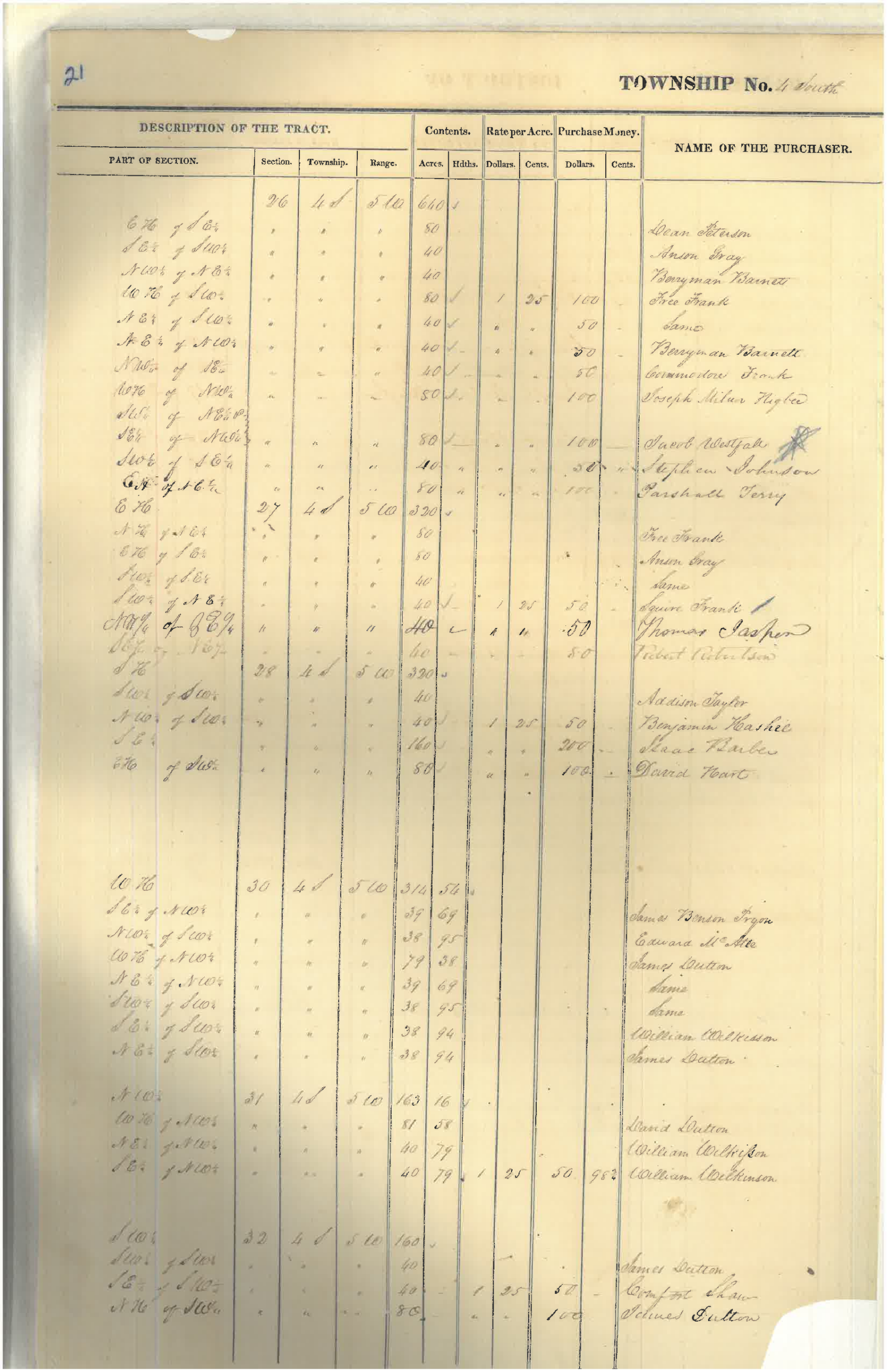
Illinois State Archives, Volume 701, page 21. Select to enlarge.
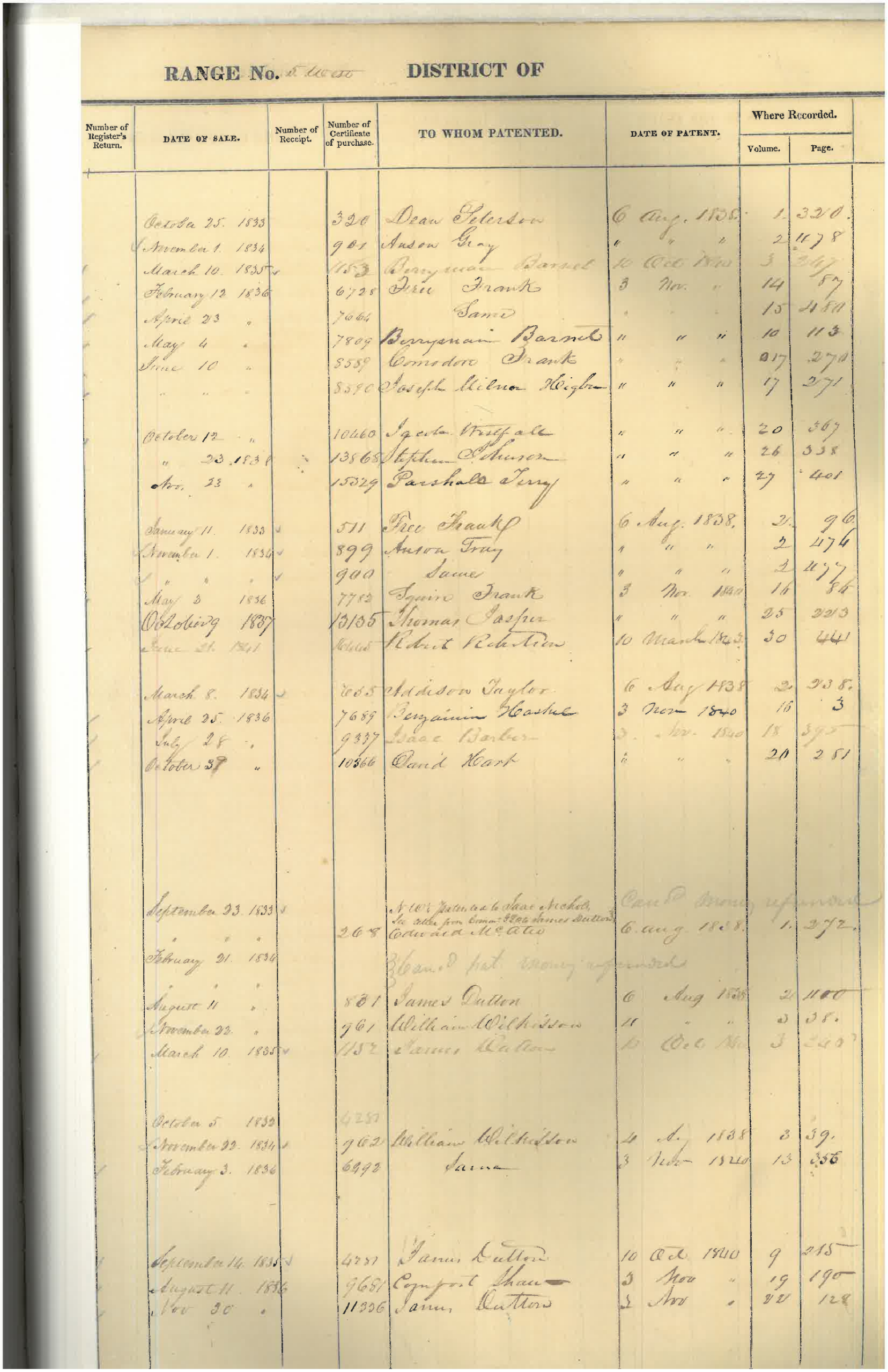
Illinois State Archives, Volume 701, page 21. Select to enlarge.
Full file: Open complete supplied PDF · Open full-size page 2 · Open full-size page 3
Evidence classification: Primary land-entry register, read with official indexed entries; not a complete subsequent title chain.
Rights note: Illinois State Archives research reproduction already displayed by BEHI. No blanket permission for further reuse is asserted; retain archival credit.
Document description: Illinois State Archives, historical land-entry register, Volume 701, page 21. The two surviving scanned pages preserve handwritten land-transaction entries associated with purchases recorded for Free Frank (Frank McWorter) on February 12, 1836 (80 acres, $100) and April 23, 1836 (40 acres, $50), in Section 26, Township 4 South, Range 5 West, Pike County, Illinois. These dates, acreages, and prices are corroborated by Illinois State Archives land-sale index records 0252560 and 0252559. The images are intended to be displayed upright for reading; the linked two-page PDF preserves the archival reproduction as received. Research boundary: A land-entry register documents recorded purchases; it does not, by itself, establish the full subsequent deed or ownership chain, which remains under investigation through BEHI Research Assignment RA002.
Illinois State Archives, original land-entry register, volume 701, page 21. The preserved two-page scan contains handwritten historical register columns. It is linked below as an original PDF, not a modern reconstruction. Its details should be interpreted alongside Illinois State Archives purchase entries 0252560 and 0252559.
Open or download the full two-page original document
Entry A: February 12, 1836 — 80 acres, $100, W2SW Section 26, T4S R5W; official Illinois land-sale entry 0252560. Entry B: April 23, 1836 — 40 acres, $50, NESW Section 26, T4S R5W; official Illinois land-sale entry 0252559.
Evidence boundary: The linked original is a photographed two-page land register. The dates, acreage and prices above are corroborated by the official indexed entries. The pages are not a complete ownership and deed chain. Some browsers may not support embedded PDF viewing; the direct document link remains available.
1837 Original Illinois Law — Legal Name and Property Rights
Act to Change the Name of Free Frank, approved January 19, 1837. Published in Laws of the State of Illinois, Passed by the Tenth General Assembly (1837), page 175. The act establishes the legal name Frank McWorter and specifically provides the right to purchase and convey real and personal property in that name. This primary legislative source supports the legal identity used for land transactions; it does not by itself establish the legal description or consideration of any individual deed.
View the original one-page 1837 law (PDF) · Transcription and historical citation — Papers of Abraham Lincoln Digital Library.
Visual reproduction pending: The original page is directly accessible as a PDF; a legible on-page image will be embedded once an approved reproduction is prepared. RA002 remains active for the underlying land-and-title chain.
Preview: The description above is a text preview. A page image has not been added to this card.
Full file: Open the complete supplied one-page PDF.
Citation: Laws of the State of Illinois, Tenth General Assembly (1837), p. 175, act approved January 19, 1837; Papers of Abraham Lincoln, D253766.
Evidence classification: Primary legislative source; legal name and stated property rights, not proof of a particular land transfer.
Rights note: Public-domain 1837 legislative publication. Repository PDF is linked; no newly reproduced page image is supplied here.
New archival source (October 2026): Illinois State Archives supplied two scans of a historical land register naming Free Frank. The entries dated February 12 and April 23, 1836 relate to the 80-acre and 40-acre Section 26 purchases already catalogued in this profile. The original register images strengthen the source record but are not evidence of additional purchases. RA002: original patent references, archival citation and subsequent title chain remain under investigation. View the original two-page Illinois State Archives land-register PDF (uploaded October 2026).
Read land evidence in layers
Identify the parcel
Match section, township, range, meridian, subdivision, and acreage—not just a surname.
Identify the transaction
Distinguish entry, patent, execution, recording, assignment, and later transfer dates.
Identify the person
Match founder, child, heir, or representative before assigning consideration or proceeds.
Evidence workflow. Database entries supply an official index record; original registers, cash-entry files, patents, and county deeds answer additional questions. In the compiled lot workbook, one transaction can occupy several lot rows. Row count is therefore not sale count, and a post-1854 Frank entry requires identity and recording-date reconciliation.
SOURCE REGISTER & EVIDENCE LIMITS
EVIDENCE & CONTEXT
| SOURCE | DESCRIPTION | DATE | EVIDENCE CLASSIFICATION | NOTES |
|---|---|---|---|---|
| Enrolled Law 2031 — name change | Primary legislative act | January 19, 1837 | VERIFIED | Illinois State Archives, Enrolled Laws No. 2031, HR 18, Box 48; delivered three-page scan reinspected. Page 1 changes Free Frank to Frank McWorter, authorizes suing/being sued, pleading/being impleaded and purchasing/conveying property under the new name, and extends the changed surname to his children. Governor Joseph Duncan approved January 19, 1837. This is an enacted act, not the underlying petition or an incorporation. |
| House Bill 3 — legislative file | Primary legislative proceedings | 1837 | VERIFIED | Illinois State Archives, 10th General Assembly, HB 3; seven-page delivered file reinspected. Page 3 committee report refers to a petition and proposes the name change; page 1 amendment addresses children; page 5 preserves a draft and legislative endorsements. The report's reference to a petition does not establish that the petition itself survives in this packet. |
| School-tax petition — file 820 | Primary petition | 1853 | VERIFIED | Illinois State Archives, 18th General Assembly, file 820; five-page delivered packet reinspected. Petition seeks education provision for children of color in relation to property-supported school funds. Signature page includes names read as C. M. Worter and S. M. Worter. It does not clearly identify Free Frank as a signer; no personal tax payment or enacted outcome is verified. |
| Martin Tanner military land patent | Primary federal patent copy | March 16, 1818 | VERIFIED | Inspected one-page file titled Martin Tanner Legal Desc. Warrant 15,424 grants Martin Tanner 160 acres, SE quarter Section 22, Township 4 South, Range 5 West, Illinois Military Tract. No assignment to Elliott or McWorter appears on this inspected face. It establishes federal origin of the tract, not the complete later chain. |
| Illinois land-sale database — FRANK FREE 0233794 | Official archival database | January 11, 1833 | VERIFIED | Current detail record inspected: FRANK FREE; N2NEMA, Section 27; T4S R5W, fourth meridian, Pike County; 80 acres at $1.25 per acre, total $100; original-entry locator volume 702, page 127. The corresponding two-page original register scan was subsequently received and inspected; its Free Frank entry corroborates the January 11, 1833 acquisition. The scan is retained pending public reproduction-rights review. Federal cash-entry files, patent chronology and subsequent title transfers remain separate research targets; an entry date is not a patent date. |
| Illinois land-sale database — FRANK FREE 0252560 | Official archival database | February 12, 1836 | VERIFIED | Current detail record inspected: FRANK FREE; W2SW, Section 26; T4S R5W, fourth meridian, Pike County; 80 acres at $1.25 per acre, total $100; original-entry locator volume 701, page 021. The corresponding Volume 701, page 21 register scans were subsequently received, inspected and displayed in Receipts, corroborating this indexed transaction. Federal cash-entry files, patent chronology and subsequent title transfers remain separate research targets; an entry date is not a patent date. |
| Illinois land-sale database — FRANK FREE 0252559 | Official archival database | April 23, 1836 | VERIFIED | Current detail record inspected: FRANK FREE; NESW, Section 26; T4S R5W, fourth meridian, Pike County; 40 acres at $1.25 per acre, total $50; original-entry locator volume 701, page 021. The corresponding Volume 701, page 21 register scans were subsequently received, inspected and displayed in Receipts, corroborating this indexed transaction. Federal cash-entry files, patent chronology and subsequent title transfers remain separate research targets; an entry date is not a patent date. |
| Federal cash certificates 511, 6728, 7664 | Prior federal research / acquisition | 1830s acquisition leads | ATTRIBUTED | Previous research links these certificate numbers to the three Free Frank parcels. Complete original case files were requested under RR1R-26-88394; delivery not confirmed here. The state database and the subsequently inspected Volume 702 register support January 11, 1833 for the first state entry. Earlier 1834/1835 readings remain in the research history; the federal file dates and patent chronology still require reconciliation. |
| Commodore Frank — certificate 8589 | Separate family acquisition | June 10, 1836 lead | ATTRIBUTED | Earlier research gives 40 acres/$50, NW quarter SE quarter Section 26. This is Commodore's separate acquisition. Exclude it from Free Frank's three-entry subtotal; original record not reinspected in this audit. |
| Elliott to Free Frank — deed | Prior deed transcription | September 13, 1830 lead | ATTRIBUTED | Pike County Deed Book 23, p. 46; earlier research and Walker's inspected reproduction describe 160 acres, SE quarter Section 22, T4S R5W, and $200 consideration. Original county page not recovered for fresh reinspection. Do not treat recited consideration as proof of a cash-only transaction. |
| Tanner assignment / tract index | Prior index transcription | Filed July 10, 1840 lead | ATTRIBUTED | Pike Book 22, p. 381 and Book 23, p. 46; earlier index reading says assigned on original. The endorsement-bearing original and intermediate transfers remain unrecovered. Do not draw a completed Tanner-to-Elliott chain from the patent face alone. |
| Joseph Porter deposition via Walker | Scholarly reproduction | March 14, 1856 deposition; 1983 publication | ATTRIBUTED | Juliet E. K. Walker, Free Frank: A Black Pioneer on the Antebellum Frontier, inspected selected pages 64–68 and note p. 188. Porter describes an exchange and Elliott acquiring from Oldham; the cited deed recites $200. Original deposition and Oldham identities require reconciliation. Smithsonian supplied scans for research; their images are not republished. |
| New Philadelphia plat locator | Government map interpretation / locator | 1836 | ATTRIBUTED | NPS identifies Pike County Deed Book 9, p. 183 and later atlas/map reproductions. Institutional accounts describe a 42-acre town and 144 lots. Original recorded plat and acknowledgment still require item-level reinspection; the town area is not total land ownership. |
| New Philadelphia land-deed spreadsheet | Compiled deed research | Historical deeds / undated compilation | ATTRIBUTED | Downloaded and inspected compiled workbook. Rows repeat a transaction across multiple block/lot entries; several Frank McWorter entries date after the founder's 1854 death. Row counts are not transaction counts; identify Frank Jr., heirs and representatives before attributing later sales. Underlying instruments and consideration must be checked. |
| Pike County deed-copy leads | Repository delivery / reinspection pending | 1830s–1850s | ATTRIBUTED | Prior copies reported received. Locators: Brown 13:274; Bixler 24:196; Burdick 27:419 and 46:468; Kittle/Kettle 43:492; Pottle 30:460; Clark 53:638 and 48:530; Squire 44:237. Individual original copies not recovered for this fresh audit; 1853–1855 chain and dates remain open. |
| Kentucky enterprise and freedom records | Original acquisition pending | 1810s–1830s leads | ATTRIBUTED | Saltpeter enterprise is described in institutional histories. Pulaski Deed Book 7-1, pp. 55–56 reportedly mentions stills, tubs and equipment; original instrument not recovered. Saltpeter and distilling evidence must remain distinct. Lucy's 1817 and Frank's 1819 freedom dates are institutional accounts until manumission/payment records are matched. |
| Family probate / freedom-purchase records | Repository lead / rights review | Later family records | ATTRIBUTED | Illinois State Museum: Squire McWorter packet 877, Commodore packet 876, and Charlotte Cowan freedom-purchase material identified in earlier work. Item dates, parties, payments and original pages need reinspection. These are family records, not automatically Free Frank's own probate or lifetime purchases. |
| NPS historical account — McWorter and New Philadelphia | Institutional interpretation | Modern institutional interpretation | ATTRIBUTED | Reports 1777–1854 life dates, Kentucky enterprise, family freedom purchases, town founding, and a cumulative 16 people/$14,000 account. The narrative includes instructions to descendants for purchases after his death; do not assert all 16 purchases were completed in his lifetime. No modern-dollar conversion is adopted. |
| Gerald McWorter family archive — finding aid | Archival finding aid | Collection donated 2026 | VERIFIED | Inspected 1542021_002.pdf, University of Illinois Archives series 15/42/21, Series 2, pp. 1–4. Identifies originals and copies of letters, deeds, photographs and later family materials, and cautions about preliminary generation labels and photograph dates. Finding aid confirms research targets, not contents of uninspected originals. No authenticated founder portrait cleared. |
| ALPLM notebooks and Kentucky charts | Repository acquisition status | Repository leads | ATTRIBUTED | Register confirms New Philadelphia notebook holdings guidance at ALPLM and charts/title-page material from University of Kentucky. Original notebook pages and chart-to-document crosswalk remain to be recovered. A genealogy chart is not a payment ledger or deed. |
RESEARCH GAPS & OPEN QUESTIONS
ECONOMIC INDICATORS — MISSING EVIDENCE
Annual operating profit
Content condition: Not yet established. McWorter enterprises
Reporting period not established
Evidence needed / present limit: Land acquisition amounts do not establish earnings from farming, production or town development.
The review below distinguishes inspected evidence, corrections and the original records still needed.
THE RECORD & ITS LIMITS
Certificate, deed, probate, repository and Kentucky leads remain visible with their inspection status.
Founder/family subtotal, entry-year conflict, law/petition distinction, assignment gap and posthumous transactions are identified.
The Volume 701 and 702 register scans have been received. Recover federal cash-entry files, endorsement-bearing patents, county deed copies, the Porter deposition, remaining freedom instruments and estate accounts.
RESEARCH UPDATES & RECONCILIATION
Manumission provenance and property leads — November 4, 2026
National Park Service ranger Quinn Gilly forwarded Claire Martin’s research and a copy of the Spencer County, Kentucky, Deed Book A manumission of Keziah and Louisa. The image was compared with the existing document description; no duplicate evidence record is added. The book page number, preferred image credit and reproduction guidance have been requested.
Pending property evidence: Martin offered citations for John Bicksler’s and Kezia’s separate New Philadelphia purchases and Kezia’s later sale of his lot. Those citations and instruments have not yet been received or inspected. A later sale alone does not establish the legal basis of inheritance.
Search variants: Martin reports Bicksler/Bixler and numerous spellings of Kezia/Keziah; Louisa/Eliza should be checked against identity records rather than automatically equated. The suggested circumstances of the families’ first meeting and reported DNA findings are unverified correspondence, not adopted historical findings.
Evidence boundary: The deed’s wording and date are distinct from the later identity chain and family narratives. No new freedom-purchase total, property value, inheritance or biological-parentage claim is established by this correspondence.
Illinois State Archives — additional land-register follow-up (October 13, 2026)
Evidence status: The original register entry is confirmed; this does not establish a later deed or complete ownership chain. The locator is not a fourth transaction.
Read full note: Illinois land-register follow-up — October 13, 2026
In correspondence to BEHI, the Illinois State Archives confirmed that Frank McWorter (Free Frank) appears three times in the public-land records previously provided, including an entry farther down the supplied page. The Archives also identified the original register locator Public Domain Land Record, Volume 702, page 127. That locator was already identified in BEHI's examination of the state land-sale database for the January 11, 1833 entry; it is not counted as a fourth transaction. The Illinois State Archives has now supplied a two-page scan of Volume 702. On the second scanned page the handwritten register lists “Free Frank” with 80 acres and a Pike County, Illinois residence; the entry corresponds to the January 11, 1833 transaction documented in the state land-sale database. The unaltered two-page scan is preserved in BEHI's primary-source receipt archive as BEHI-P009-FFM-IL-LAND-V702, with provenance metadata and a SHA-256 integrity checksum. The original archival image is retained internally pending a separate review of public reproduction rights. This confirms the original register entry but does not establish a subsequent deed or complete ownership chain.
Ownership-chain research: The State Archives advises that later sales and conveyances should be pursued in older county deed records through the Illinois Regional Archives Depository (IRAD) system. BEHI is targeting Pike County deeds to verify grantor, grantee, legal description, consideration, execution and recording dates, and intervening ownership. The later chain of title remains unresolved.
Evidence status: Archival correspondence and existing state database entries identified; original Volume 702 register scan received and inspected; subsequent Pike County conveyance deeds pending. No new ownership or acreage claim is inferred from this correspondence.
Evidence status: Reported 1858 transactions remain secondary-source findings; original deeds and their terms still require verification.
Read full note: Previous research and estate-transfer leads reconciled
Act, bill file, petition, patent face and official entries.
Scholarship, institutional interpretation and compiled deed research.
Cash-entry files, endorsements, county deeds, payments and probate.
Have a document that could help? Contact BEHI with its source and provenance. Submissions are reviewed before inclusion.
PREVIOUS RESEARCH RECONCILED
Have a document that could help? Contact BEHI with its source and provenance. Submissions are reviewed before inclusion.
New source and research gaps (October 19, 2026): University of Maryland, New Philadelphia Archaeology: Report on the 2010 Excavation, Fig. 1.1 (published reproduction of plat from Pike County Deed Book 9:183) and 1858 estate-transfer discussion/Table 3.1. Read scholarly source. Obtain both original 1858 deeds; authenticate execution and recording dates, grantor authority, signatures, named buyers, payment, 72-lot schedule and Block 2 exclusion. Reported transactions remain secondary-source findings, not independently verified original deeds.
No verified records are currently published in this category.
Cite This Profile
The Black Economic History Institute (BEHI) Digital Archive